Category: Maps
-

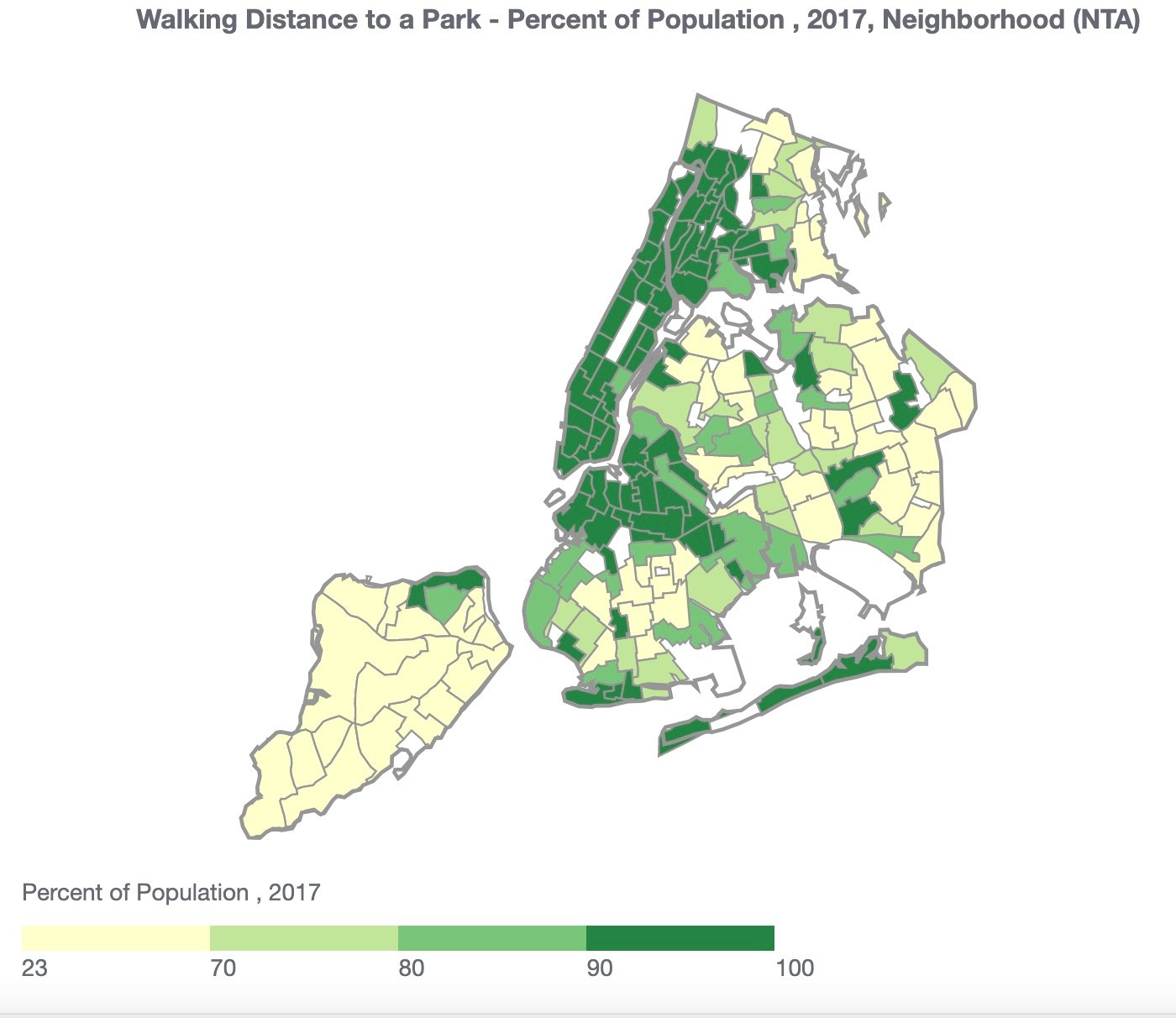
Walking Distance to a Park
How Calculated: A map of “walk-to-a-park service areas” from the NYC Parks Department was overlayed onto a map of 2017 population estimates by census tract to calculate the percentage of the population that potentially live within the service area. These percentages were aggregated up to a neighborhood level. Source: New York City Department of Parks and Recreation,New…
-

Where Did Eric Adams Campaign
The City newspaper has tabulated the 800 campaign stops that Adams, Kathryn Garcia, Maya Wiley and Andrew Yang made around the five boroughs between April Fools’ Day and Primary Day. After months of seemingly endless online forums, the location of these campaign stops is fascinating and tells you a lot about who they saw as…
-

Chicken Egg
When NYS’s OASAS agency oversaturates struggling communities with opioid treatment programs it justifies this by looking at addiction rates. What OASAS fails to acknowledge or admit to local community boards and politicians, is that they’ve already oversaturated struggling communities, and want to add more capacity to avoid the more difficult process of equitably locating programs…
-

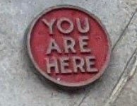
Randalls Island
At the base of the Triborough bridge (where the pedestrian walkway starts in Astoria) there is a wonderful, vintage and cast metal map of Randalls Island: Note the red button on the right-hand side that indicates where you are. Note how Wards Island was not ‘open’ to the public (greyed out) and had a dock…
-

Mice and Rats!
Yikes! MacKenzie Scott Donates to El Museo and The Studio Museum MacKenzie Scott, one of the richest women in the world, promised to keep giving her fortune away “until the safe is empty” following her divorce from Jeff Bezos in 2019. Over the past year, Scott has donated some $6 billion to more than 500…
-

Cockroaches!
Yuck! June is Anti-Gun Violence Month Join the National Action Network’s incredible work on the plague of gun violence at an anti-gun meeting today at 12:30.
-

Shootings
Residents of some neighborhoods are at much greater risk of experiencing violence – and its many health effects. Violence is rooted in historical disinvestment and racism. Evidence shows that violence results from social structures that limit access to basic needs – structures that are fueled by racism, residential segregation, and neighborhood disinvestment. Where these structures…
-

Risk of Crime
(The risk of crime being indicated by red on the map below) The map of white-collar crime is a telling one. Most of the criminals commit their crime in midtown or the financial district. Harlem has a relatively low crime rate by this measure. To explore where you are most at risk for this form…
-

Infant Deaths
How Calculated: Number of deaths occurring at less than 1 year of age in an area, divided by the number of live births among resident mothers of the area; expressed as cases per 1,000 live births. Infant deaths are restricted to those that can be linked to a birth certificate of a NYC resident mother…
-

Borough President
A borough president is an advocate for their borough in a number of ways. First, they have a sizable chunk of change at their disposal to fund local initiatives, groups and projects like buying technology for public schools, renovating local parks or spearheading community health outreach. Borough presidents share about 5% of the city budget…
-

The Commute
Opioid Treatment Commuters – travel patterns and patient numbers (commuting into East Harlem) from all 5 boroughs are illustrated on this map. Hover over a zip code on the map below to learn how many travel (often daily) to East Harlem for their treatment. Extreme Heat Is Coming (okay, this weekend isn’t super hot, but…
-

Speeding Drivers
How Calculated: Estimated percent of adult drivers (drove in the last 30 days) who responded “often”, “sometimes” or “rarely” to the question: “In the past 30 days, when you drove in New York City, how often did you drive 10 miles per hour or more over the posted speed limit?” Source: New York City Community Health Survey (CHS)…