Category: Maps
-

Harlem Rents Near Subways
Renthop has an analysis of rent price increases for apartments close to subways. Looking at the 2/3 Lenox/125 station, the nearby rent increased by 18.4%: The 4/5/6 transit area increased by 17.8%: But the largest increase was near the A/B/C/D 125th Street station. Rents there increased by 20.3%: If you’re wondering, the Harlem rents near…
-

1950 Census, Released
On April 1st, the 1950 US Census was released to the world. US law only releases the detailed/full census details 72 years after the census year. Thus 2022 is the year for the 1950’s census full debut. If you want to find detailed information about relatives or others, you can start here at this site:…
-

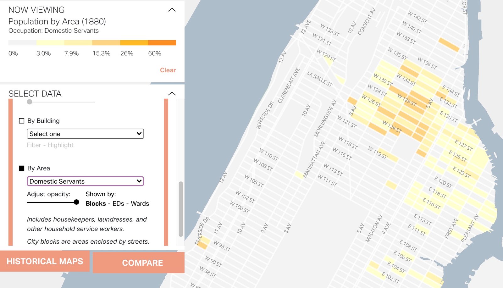
Craftspeople, Doctors, and Domestic Servants in 1880
Mapping Historical New York allows you to look at the geographic distribution of trades in 1850, 1880, and 1910. Given how sparsely Harlem was settled in 1850, it’s really only the 1880 data and beyond that shows clear patterns. This first map is of Craftsmen in 1880. Note their presence in the Upper East Side…
-

Evictions
The impact of COVID-19 will be felt for decades to come. A look at eviction filings in New York show the plummet to near 0 in the early days of the pandemic: To get a sense of how this graph of 2020 compares to filings in pre-pandemic 2019, see: Removing 2020 (a highly anomalous year)…
-

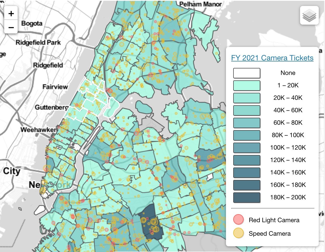
Speeding and Red Light Cameras
Streetsblog has a fascinating article on how speeding and red light cameras function in light of conversations about bias in policing and traffic enforcement. The map of traffic cameras shows that relative to the rest of the city, few tickets are given in Harlem and East Harlem by these automated systems. In the map below,…
-

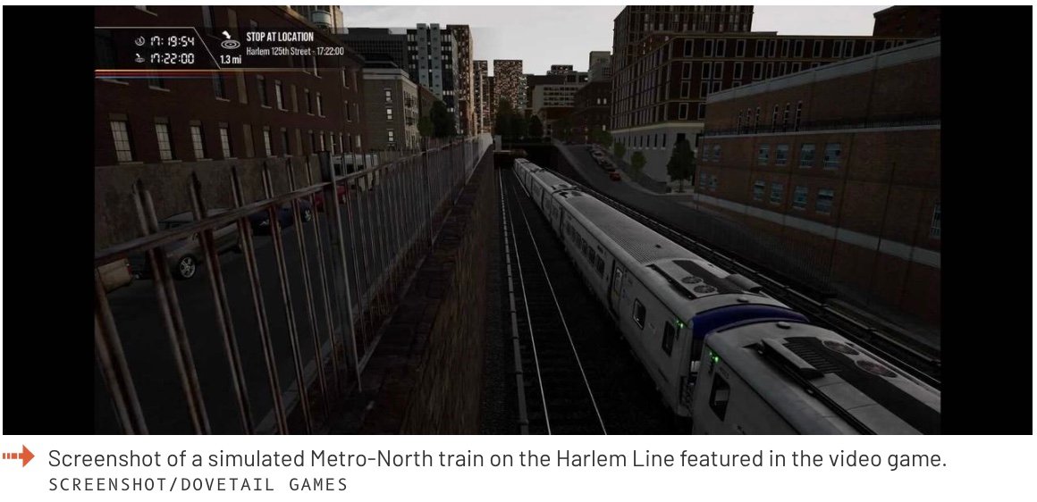
Drive Metro North
If you’ve ever taken Metro North and wondered what the view would be like at the front of the train – driving it – there is a new video game out that allows you to drive a train from Grand Central to Harlem, and then up to White Plains In the screenshot below you see…
-

Disadvantage
The US Government has a climate and economic justice map of ‘disadvantage’ which looks at census tract information and collates a variety of factors that indicate disadvantage or advantage. The resulting national map is fascinating to explore to not only see where these census tracts are, but the data that underlies the designation. Communities identified…
-

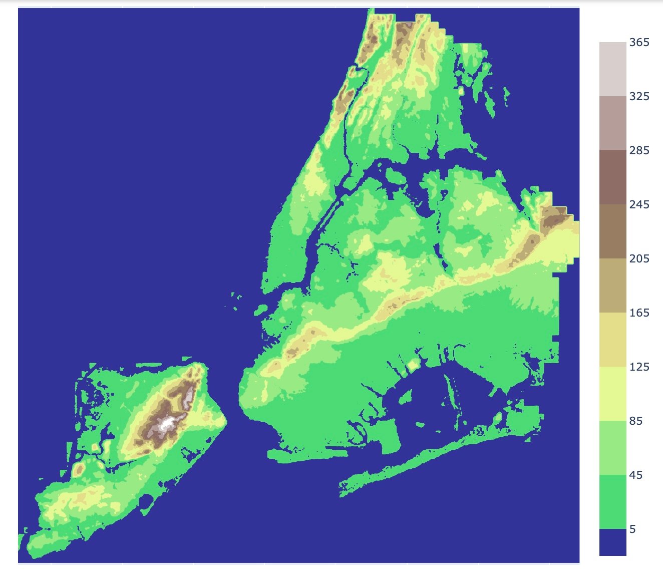
New York, Stripped Bare
If you’ve ever wondered what NYC would look like, if stripped of all the buildings, here’s the map: Note how Harlem is mostly in the 5′ – 45′ above sea level range, except for Morningside Heights and St. Nicholas Park and the City College campus area: And that little dot in the middle of the…
-

Harlem Creek
Before the building boom in the 2nd half of the 19th century, what we call Central Harlem was farmland where people raised cash crops to sell 7 miles south in New York City. It was sleepy, undeveloped and could easily pass for rural New England today: This 1870 photo is looking northwest from what’s left…
-

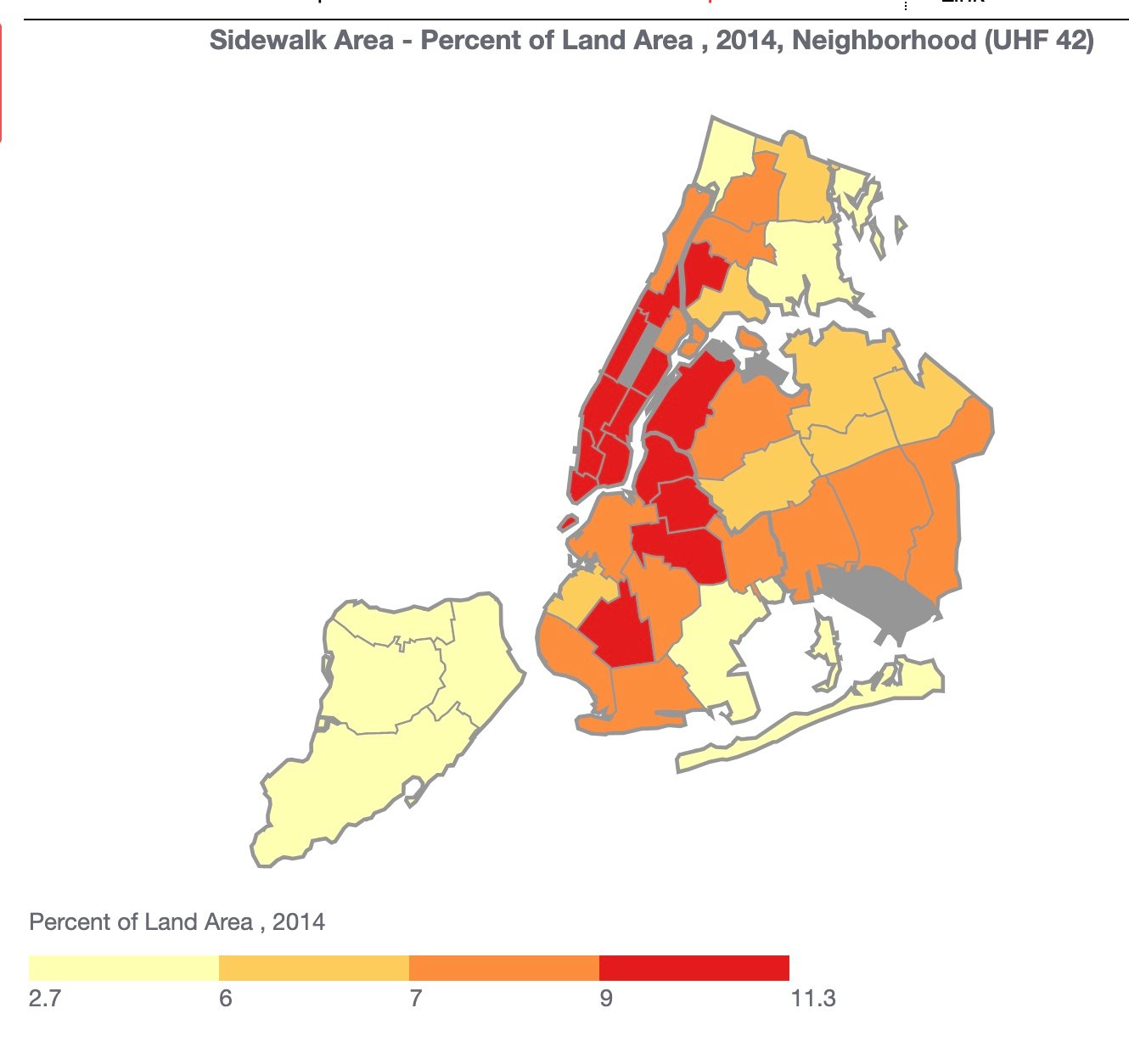
Sidewalks by Neighborhood
Sidewalks are a critical component of New York City residents’ commute. Ample sidewalks in neighborhoods are important for commuting, businesses, and physical activity. Greater sidewalk area facilitates safer pedestrian traffic that, in turn, attracts businesses and fosters community. “Sidewalk area” measures the percent of a neighborhood that is covered by sidewalk area. About the Measure…
-

Average Commuting Time
The variation in mode share across the city is not surprising given that some neighborhoods have access to many modes (convenient transit, bikeshare, etc.) while others have fewer options and are more car-dependent. Likewise, average commute times vary widely among neighborhoods, from just over a half hour to just under an hour. Residents may face…
-

Split!
The Harlem Neighborhood Block Association has a foot in two political doors – State Assembly District 68 (formerly held by Robert Rodriguez) , and State Assembly District 70 (held by Inez Dickens). To see which district you’re in (and yes, the boundaries just changed with the whole redistricting process), take a look at the two…